• Skip to Management
  • Skip to Main menu
  • Skip to Page content
Adlershof Logo
  • WISTA
  • WISTA.Plan
  • WISTA.Service
WISTA direkt
Search
  • de
  • en
  • Adlershof Logo
  • About / Directory
    • Companies / Institutes
    • Science City in numbers
    • Direction / Maps
      • Bus / Train
      • By Car
      • Bicycle
      • Orientation / Maps
      • Trail of Thoughts
  • Newsroom
    • Overview
    • News
      • Social Media Stream
      • Success Stories
    • Events / Calendar
      • Adlershof Dissertation Award
      • Adlershof Research Forum
      • Long Night of Sciences Berlin
    • Adlershof Journal
    • Hot Topics
      • Adlershof Mission "Grand Challenges"
      • Circular Economy
      • Digital infra­structure / 5G campus network
    • Photos / Flyer / Downloads
      • Magazine archive
    • WISTA-Editorial Staff
  • Science / Technology
    • Overview
    • Technology Centres
      • Photonics / Optics
      • Biotech­nology / Envi­ron­ment
      • Micro­systems / Materi­als
      • IT / Media
      • Renewable Energy / Photovoltaics
    • Non-university Research
    • Universities / Colleges
      • Humboldt-Universität zu Berlin
      • Services for Students
    • Young Talents / STEM / School Labs
    • Start-Ups
      • Adlershof Start-Up Centre IGZ
      • Adlershof Founder’s Lab
    • Networks / Management
      • Campus Club Adlershof
  • TV / Media
    • TV and Movie Production
    • Media Services / Companies
    • News and Events
    • Filming Locations
    • Costume Hire
    • GDR Film Archive
    • Tickets / Booking
  • Properties
    • Overview
    • Real Estate Rent
      • Office Space / Workspace / Laboratories
    • Real Estate Offers
      • Commercial Properties
    • ST3AM Working Environments / Coworking
    • Residential
    • Construction
      • Building Projects
      • Architecture
      • Webcam
  • Service
    • Overview
    • Gastronomy / Sport / Culture / Shopping
    • Jobs / Market
    • Social and Healthcare Facilities
    • WISTA-Business Services
    • Event Services / Guided Tours / Hotels
    • Facility Management
    • Downloads / Photos / Videos
    • Jobs for Refugees
  • Hood
    • Overview
    • History
    • Nature Park
    • Culture
    • Technology Park
    • Digital Tours
  • WISTA
  • WISTA.Plan
  • WISTA.Service
WISTA direkt

News

  • Overview
  • News
  • Events / Calendar
  • Adlershof Journal
  • Hot Topics
  • Photos / Flyer / Downloads
  • WISTA-Editorial Staff
  • Adlershof
  • Newsroom
  • News
13. June 2024

Real-time situation maps for disaster management

DLR creates live situation maps for international exercise for the first time and analyses data with open source AI

  • The Swiss Rescue team during night-time search and rescue operations © I.S.A.R. Germany
    The Swiss Rescue team during night-time search and rescue operations © I.S.A.R. Germany
  • Screenshot UN-INSARAG situation system ICMS. Credit: DLR (CC BY-NC-ND 3.0)
    Analysis using artificial intelligence: The live images from the drone and the objects detected using AI were transmitted in real time to the UN-INSARAG situation system ICMS and thus made available to the situation team and the local relief workers. Credit: DLR (CC BY-NC-ND 3.0)

From 21 to 25 May 2024, the German Aerospace Center (Deutsches Zentrum für Luft- und Raumfahrt; DLR) took part in the international disaster relief exercise ACHILLES 2024 in Switzerland. For the first time, a team from the DLR Institute of Optical Sensor Systems succeeded in creating a live map image of the exercise area and analysing it using AI. The information was then transferred to the United Nations' Coordination Management System (ICMS) and utilised by all participating teams.

An emergency scenario under realistic conditions

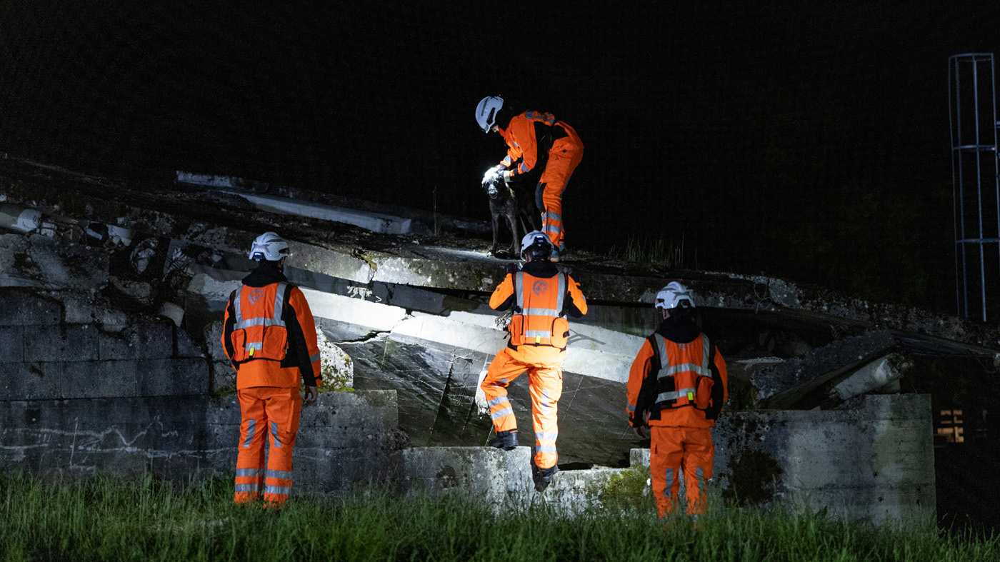
The disaster scenario simulated an earthquake with a magnitude of 7.1 on the Richter scale that resulted in people buried and missing. The five participating international teams of aid and rescue workers needed to be deployed and coordinated in a targeted manner. DLR accompanied the non-profit aid organisation I.S.A.R. Germany during the exercise as the drone operations team. As part of the operation, the DLR team controlled a MACS-nano camera on board a drone over the disaster area and created a live map using real-time mapping. During the flight, the high-resolution aerial images were georeferenced and continuously transmitted to the ground. Georeferencing gives the digital image a spatial position by assigning each pixel a geographical longitude, latitude and altitude on Earth's surface.

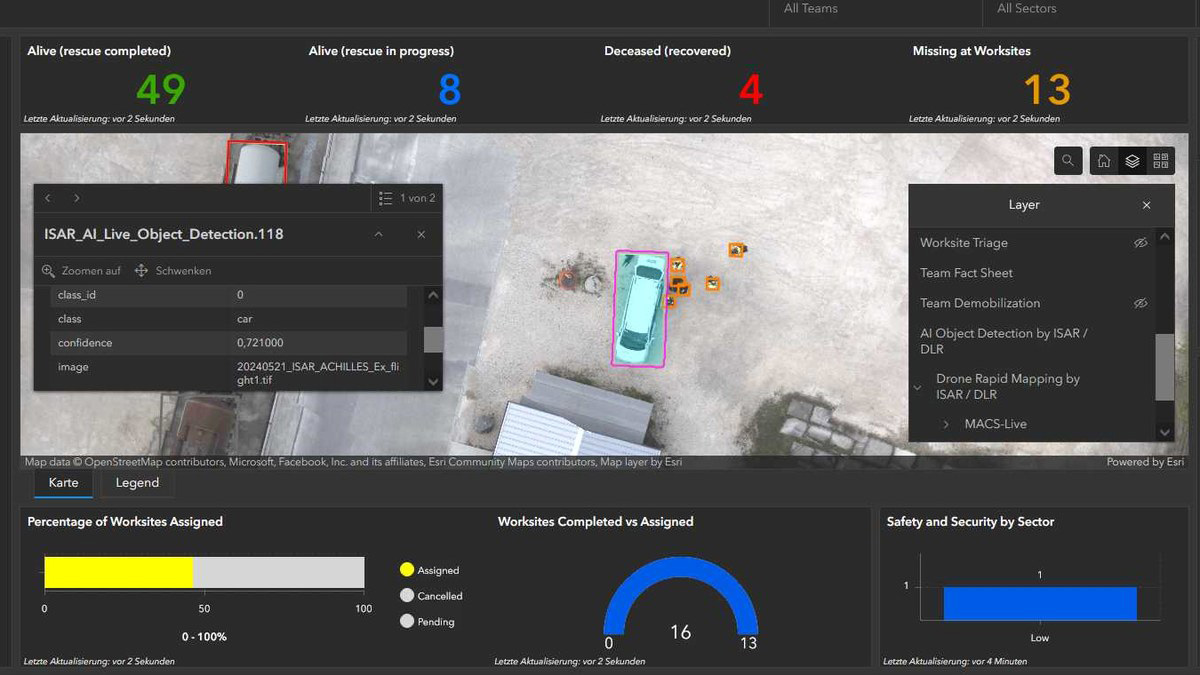
The generated situation map was transferred directly to the Coordination Management System (ICMS) via a Starlink terminal and used by all participating teams. The ICMS is an emergency management system that is used to process and visualise relevant data and information. This information is uniformly available to all participating organisations in a disaster area and is used to coordinate emergency teams and resources, assess the extent of the damage and prioritise deployment locations.

First map evaluation using AI

In a world first for this type of exercise, the situation map was analysed directly in the emergency area using AI methods and then made available in the ICMS. The open source software was able to automatically detect objects relevant to the search and rescue work of the disaster relief workers. For example, clusters of people and various types of vehicles such as cars, vans, trucks and excavators were identified and localised by the AI model.

The results were provided with a short delay as a web feature layer for use as geoinformation in the ICMS. The use of AI processes significantly speeds up the initial evaluation of the image data compared with manual inspection and interpretation.

Multi-agency collaboration for disaster management

From the outset of the exercise, the three layers of the situation imagery provided by DLR (RGB map, thermal infrared map and AI geoinformation) were made available to all participating teams in the ICMS by the INSARAG Mapping Group of the United Nations. DLR and the non-profit aid organisation I.S.A.R. Germany have been cooperation partners since 2016. Together, new technical developments for use in crisis and disaster management are being trialled and deployed in real-life disaster situations.

Contact

German Aerospace Center (DLR)

Diana Gonzalez Velden
Communications & Media Relations
Web Editor
Linder Höhe, 51147 Köln
+49 228 447-388

Thomas Kraft
Institute of Optical Sensor Systems
Security Research and Applications
Rutherfordstraße 2, 12489 Berlin-Adlershof
www.dlr.de/en/os


Press release DLR, 11 June 2024

Traffic / Aerospace Photonics / Optics Digitalisation IT / Media Research Grand Challenges

Related News

DLR project ComInA: tracking system for emergency responders © DLR

Better coordination of emergency services in buildings

DLR tracking system makes people and surrounding structures visible
  • LinkedInshare0
  • Facebookshare0
  • WhatsAppshare0
  • E-Mail

The development of the Science and Technology Park Berlin Adlershof was and is co-financed by the European Union namely by EFRE. This concerns infrastructure development like construction of technology centres. Furthermore EFRE is used for international projects.

  • © WISTA Management GmbH
  • Legal Notice
  • Privacy Policy
  • Social Media Guide
  • FAQ
  • Contact
  • Press
  • Newsletter
  • RSS
  • International
Member of:
Zukunftsort Adlershof Logo