• Skip to Management
  • Skip to Main menu
  • Skip to Page content
Adlershof Logo
  • WISTA
  • WISTA.Plan
  • WISTA.Service
WISTA direkt
Search
  • de
  • en
  • Adlershof Logo
  • About / Directory
    • Companies / Institutes
    • Science City in numbers
    • Direction / Maps
      • Bus / Train
      • By Car
      • Bicycle
      • Orientation / Maps
      • Trail of Thoughts
  • Newsroom
    • Overview
    • News
      • Social Media Stream
      • Success Stories
    • Events / Calendar
      • Long Night of Sciences Berlin
      • Adlershof Dissertation Award
      • Adlershof Research Forum
    • Adlershof Journal
    • Hot Topics
      • Grand Challenges
      • Circular Economy
      • Digital infra­structure / 5G campus network
    • Photos / Flyer / Downloads
      • Magazine archive
    • WISTA-Editorial Staff
  • Science / Technology
    • Overview
    • Technology Centres
      • Photonics / Optics
      • Biotech­nology / Envi­ron­ment
      • Micro­systems / Materi­als
      • IT / Media
      • Renewable Energy / Photovoltaics
    • Non-university Research
    • Universities / Colleges
      • Humboldt-Universität zu Berlin
      • Services for Students
    • Young Talents / STEM / School Labs
    • Start-Ups
      • Adlershof Start-Up Centre IGZ
      • Adlershof Founder’s Lab
    • Networks / Management
      • Campus Club Adlershof
  • TV / Media
    • TV and Movie Production
    • Media Services / Companies
    • News and Events
    • Filming Locations
    • Costume Hire
    • GDR Film Archive
    • Tickets / Booking
  • Properties
    • Overview
    • Real Estate Rent
      • Office Space / Workspace / Laboratories
    • Real Estate Offers
      • Commercial Properties
    • ST3AM Working Environments / Coworking
    • Residential
    • Construction
      • Building Projects
      • Architecture
      • Webcam
  • Service
    • Overview
    • Gastronomy / Sport / Culture / Shopping
    • Jobs / Market
    • Social and Healthcare Facilities
    • WISTA-Business Services
    • Event Services / Guided Tours / Hotels
    • Facility Management
    • Downloads / Photos / Videos
    • Jobs for Refugees
  • Hood
    • Overview
    • History
    • Nature Park
    • Culture
    • Technology Park
    • Digital Tours
  • WISTA
  • WISTA.Plan
  • WISTA.Service
WISTA direkt

News

  • Overview
  • News
  • Events / Calendar
  • Adlershof Journal
  • Hot Topics
  • Photos / Flyer / Downloads
  • WISTA-Editorial Staff
  • Adlershof
  • Newsroom
  • News
01. September 2025

DLR researchers publish open-source tool for assessing urban transport connections

Improved access to public transport is one of the United Nations’ sustainable urban development goals

Figure: Exemplary results of PtAC calculations for the city of Manila
Exemplary results of PtAC calculations for the city of Manila: On the left, the spatial distribution of population points and the computed distances to the nearest public transport stop are shown in blue. Right: Cumulative population share by distance to public transport. Credit: DLR (CC BY-NC-ND 3.0)

The United Nations adopted the 17 Sustainable Development Goals (SDGs) in 2015. These goals are to be implemented globally in order to promote sustainable peace, prosperity and protection of our planet by 2030. One of these goals is improved access to public transport, defined in section 11.2.1. The implementation of this goal in particular is often difficult due to a lack of standardised methods, technical expertise and data.

Automated calculation of urban transport connections

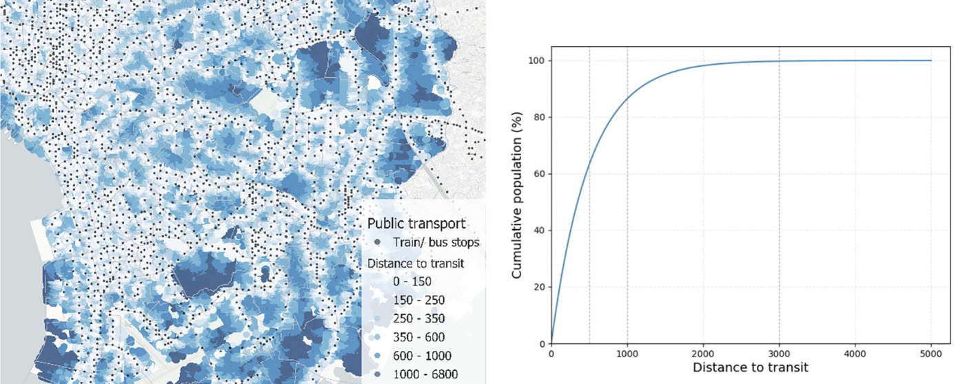
Researchers at the German Aerospace Centre (DLR) have developed the open source tool “Public Transport Access Calculator (PtAC)” as a solution. PtAC makes it easier for cities to track their progress towards achieving SDG 11.2.1. The open-source Python library combines remote sensing data from the World Settlement Footprint Population (to calculate population density in cities) with crowdsourced geodata from OpenStreetMap (to identify road networks and public transport). PtAC automates the calculation of SDG 11.2.1 and enables a globally applicable, transparent and reproducible approach to consistently monitor urban transport connectivity.

“PtAC is an important step towards a more sustainable future,” emphasise the developers of PtAC Simon Nieland, Mirko Goletz, Daniel Krajzewicz and Daniela Palacios Lopez. “With PtAC, cities can more easily track their progress towards achieving SDG 11.2.1 and make data-driven decisions.”

Effective with limited resources

The researchers tested PtAC in 33 cities worldwide and compared the results with reference values from UN-Habitat, the United Nations Human Settlements Programme. UN-Habitat collects data on global urban developments and parameters on an annual basis. PtAC has proven to be an effective tool for assessing SDG 11.2.1. The results show that there is a high correlation with the United Nations reference values. The study also shows that the method is particularly relevant for cities with limited resources.

With PtAC, local governments have a scalable tool for independent and constant progress analysis of their commitment to the UN Sustainable Development Goals without the need for specialised GIS skills. It provides a cost-effective way to support the prioritisation of infrastructure investments in areas of high need and potentially facilitate access to global funding linked to SDG performance.

PtAC is an open source tool and can be used by anyone free of charge.

Github: https://github.com/DLR-VF/PtAC

Publication: Introducing PtAC – an open source tool to assess SDG 11.2 using open data - ScienceDirect

Contact:

German Aerospace Center (DLR)
Institute of Transport Research
Rudower Chaussee 7, 12489 Berlin
www.dlr.de/vf


DLR press release, 21.08.2025

Research Grand Challenges Mobility Sustainability Traffic / Aerospace

Related News

Please mind the gap

Three DLR researchers highlight gender-specific knowledge gaps that prevent the surveying of women’s needs in cars, busses, and trains

Related Institutions

  • Deutsches Zentrum für Luft- und Raumfahrt e.V. (DLR), Standort Berlin

Share this page

The development of the Science and Technology Park Berlin Adlershof was and is co-financed by the European Union namely by EFRE. This concerns infrastructure development like construction of technology centres. Furthermore EFRE is used for international projects.

  • © WISTA Management GmbH
  • Legal Notice
  • Privacy Policy
  • Social Media Guide
  • FAQ
  • Contact
  • Press
  • Newsletter
  • RSS
  • International
Member of:
Zukunftsort Adlershof Logo